
The Cherokee lived in North Georgia until the 1830s, when they were forcibly removed in what came to be known as the Trail of Tears.[1] In 1832, the State of Georgia surveyed the Cherokee lands to prepare for a lottery, where settlers would be given randomly selected plots of land across North Georgia. The region was divided into four sections, which were divided into districts, which were divided into lots. Modern Cobb County still uses these districts and lots in surveying and property records.
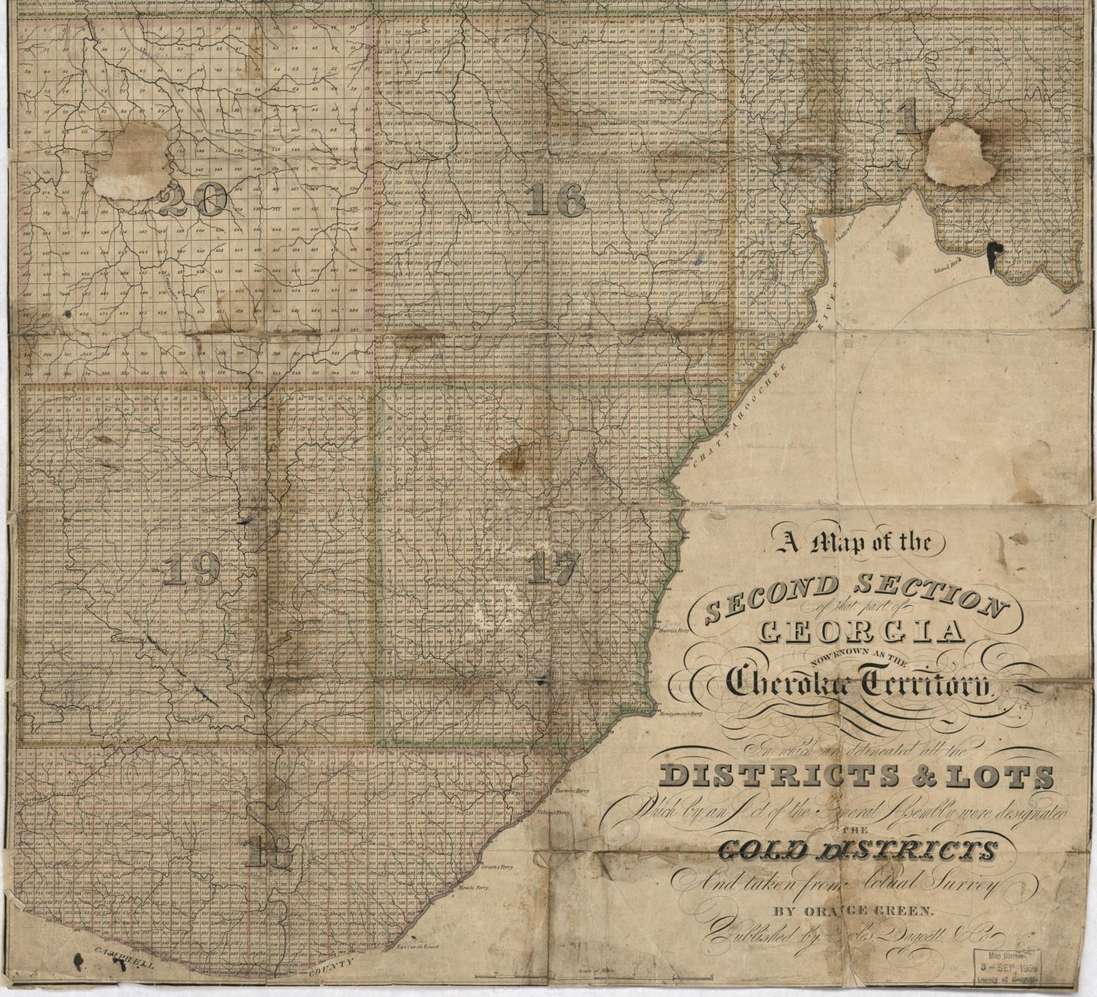
Cobb County was in the Second Section of the old Cherokee lands, in districts 1, 16, 17, 18, 19, and 20. The detailed maps they made still survive and can be found on the Georgia Archives website. However, the District 1 map does not survive or was not digitized.
On the surviving maps, the surveyors marked the Cherokee trails and paths throughout the county. Perhaps the most prominent was the Peachtree Trail, which connected the village of Standing Peachtree (northwest of modern Atlanta) with the Cherokee capital of New Echota (near modern Calhoun). Many other Native American paths throughout the county are still in use today as modern roads.
The surveyor for District 20, John W. Cowart, went one step farther on his map and included existing white and Cherokee settlements. (NOTE: See addendum at the end of this post for clarification). His notes offer valuable insight into what North Cobb was like before the Cherokee removal. Because each district had different surveyors, the paths they marked did not always align with other maps. This is especially the case in District 19, where no path entering the adjoining districts matches perfectly, and some paths stop completely on reaching District 19.
Research has been done before on the Cherokee paths in Cobb County, but is not available online. Recently, I decided to take scans of the original survey maps and see what it would look like on a current map. By recording the land lots the trails passed through and comparing it with a modern Cobb County map of land lots, I created the map below.
For a more interactive version that works best on the computer, click here. Note that in version at the link, the options on the left allow you to remove the county boundary, allowing you to click on the Cherokee trails to see more information. You can also add in the land district boundaries.
I cannot guarantee that this map shows exactly the route of every Cherokee path, but the locations should be accurate as to which land lots had roads passed through. Basically, where the path crossed into a new land lot, a pinpoint was placed on the border. I would keep placing pinpoints down the route of the path, and then I would connect the dots.
In green, the Peachtree Trail is cutting through the center of the county. It crosses the Chattahoochee at Montgomery’s Ferry near Bolton (see my post on Bolton for more information) and continues up Atlanta Road through Smyrna and into Marietta. Note that close to the river, it follows Log Cabin Road (the old Atlanta Road) instead of the newer highway. From the Marietta Square, it heads north up Kennesaw Avenue to Old 41, becomes Kennesaw’s Main Street, and eventually travels near Acworth. Notably, the Peachtree Trail and Acworth’s Main Street are very different routes, possibly indicating that Main Street was rerouted to hug the railroad tracks.
Also important is Shallowford Road, which in the northeast corner of the county is connected with one of the Old Alabama Roads. Several routes of the Alabama Road were in North Georgia in the 1830s, and many still survive today under various names. More information can be found in articles by Marion Hemperley in the North Georgia Journal of History, Volume II.[2]
In District 20 near Kennesaw and Acworth, I have added the white and Cherokee settlements. You can see how they are originally depicted on Cowart’s map by clicking on each point. It is especially interesting to see the string of Cherokee settlements now underneath Lake Acworth. The largest settlement recorded is the “Indian Improved 40 acres” just south of Kennesaw State University.
In preparation for the nation’s bicentennial, Dr. Phillip Secrist created a map of historic sites across Cobb County, including several historic roads and Cherokee towns.[3] His version of Shallowford Road is different than what is depicted on the original maps and is included in yellow near the Cherokee County border. He identified three villages across the county: Kennesaw Town, near modern Kennesaw; Sweetwater, near modern Austell; and Buffalo Fish Town, near today’s Truist Park. Each town is also mentioned in Rev. George White’s 1855 book Historical Collections of Georgia. These locations are marked in yellow. Where Secrist placed Kennesaw Town matches with several white settlements documented by Cowart, and the location of Sweetwater Town is where several paths Cherokee paths converge. Buffalo Fish Town, however, is more elusive, as its location is not along any trail. I am suspicious the location should be closer to Smyrna, where several routes join the Peachtree Trail.
The only data not coming from the 1832 map is marked in yellow. Some of these are circles offering additional information or points of interest. The paths in yellow are my best approximations of missing paths when a route crosses a district line and vanishes.
Overall, I hope this map offers an interesting addition to the study of the Cherokee in Cobb County. While some similar work has been done before, I hope this interactive version makes it easier to see how many of these roads still exist in our area.
Addendum: August 25, 2025
When I first wrote this post, I had only read select portions of Marion Hemperley’s Historic Indian Trails of Georgia (1989). I recently decided to read the entire book, and thought a correction was required for this post after reading the section on Coweta. Hemperley says that Creek town was, in fact, two settlements, a “red” town and a “white” town. The former was focused on war, while the latter was focused on peace. I was curious if this also applied to the Cherokee, and a quick Google search found a reference in the Encyclopedia Britannica that this was also a Cherokee custom.
What concerned me about this was the District 20 survey map. The towns depicted are colored red and what I thought was white. This left me wondering if I had misinterpreted the map, and what I thought were white vs. Native American settlements were actually red and white Cherokee towns. This would clarify an important question: why is the town of Kennesaw described by Rev. George White depicted on the survey map as a white village?
However, a look at the key of the survey map holds one final clue: “Indian Residences painted Red + home of the whites Blue the figure in each intended to represent the number of acres.” Over time, the blue that the key describes has faded to white in many places. Cowart was, in fact, representing Cherokee and white settlements in Northwest Cobb. Even though my concern proved to be unfounded, I felt it best to leave a note here offering clarification in case the issue of red and white Cherokee towns arises in the future.
[1] Trail of Tears: The Rise and Fall of the Cherokee Nation by John Ehle is a very good work on the subject.
[2] Thank you to Larry Davis and John Tanner for making me aware of these articles. For more information about Native American paths across the state, see Hemperley’s book Historic Indian Trails of Georgia.
[3] I don’t have a copy of the map close by, so I am instead using a map created with it for Darlene Roth’s Architecture, Archaeology and Landscapes: Resources for Historic Preservation in Unincorporated Cobb County, Georgia.
Interested in subscribing to my blog? Type your email below to be notified about new posts.

One thought on “Cobb County, 1832”
Comments are closed.